


Mount Fuji climb and Kawaguchiko
Fujisan climb and visiting Five Lakes area was in my plans for the last 5 years. Actually I was planning to realize my plan in 2018 and arranged everyhing including flight, accomodation etc. but I could not because of the weather conditions (heavy rain, flood) in Japan.
Of course I did not give up and realized it in July 2019:)
In this page, I will share some photos from this trip, tell you about my plan and try to give some tips and useful links for Mount Fuji climb.

Panoramic view of the crater at Mount Fuji summit
My Trip Plan
Climbing Mount Fuji was the main reason for my third visit to Japan so I planned everything accordingly. I made my research and planned my trip according to the following criteria. You can find all details about Fujisan climb in the official site of Mount Fuji climbing.
- Mount Fuji is open for public for a limited time every year. Climbing season is between the start of July and mid of September but for the exact timing you can check this link.
- Some days in climbing season is very crowded and you may want to avoid these days like weekends, festivals and special days. Also the summit is very crowded during sunrise and there is a high risk of stucking in the crowd during sunrise and not being able to see it. You can check this link for the prospect of crowded days.
- Weather conditions may change hourly and daily at Mount Fuji and this may block all of your plans about climbing. It is better to have a few optional days for the climb.
- It is recommended to rest during the climb and spend the night at a mountain hut. Bullet climb is not recommended.
I made all of my plans according to therese criterias except the last one. I preferred the bullet climbing because I did not want to spend 2 days for the climb and wanted to avoid sunset crowd. If you trust your physical conditions you may consider bullet climbing (ascending and descending in the same day) but it is a decision only you can take.
Here is my plan for the whole trip:
- 8th of July: Flight from İstanbul to Tokyo and spend the night at Tokyo in an airport hotel.
I chose this date for the beginning of my trip because the start of the climbing seaseon may be postponed in the first week of July due to the weather conditions and August is a more crowded period for the climb. Also I selected an airport hotel becasue there are more options from airport to reach the Mount Fuji area. I stayed at Marroad International Hotel Narita - 9th of July: Bus trip from Tokyo Narita airport to Kawaguchiko, it takes 3 and a half hours.
You can reach to one of the options for bus trip in here. - 9th of July and 12th of July: Stay 3 nights in a hotel in Fujikawaguchiko.
Kawaguchiko is the best option for Mount Fuji climb because it is easy to reach Mount Fuji 5th station (where the climbing route starts for Yoshida trail) from Kawaguchiko bus station. Also I preferred to stay here for 3 nights because I wanted to have 2 alternative days for the climb in case of a weather conditions problem. I stayed at Fuji View Hotel - 10th or 11th of July: Climb Fujisan.
I made it on the 10th of July in a perfect weather. - 12th of July: Back to Tokyo by bus and spend 2 days in Tokyo
- 14th of July: Back to home, İstanbul.

2 hours to the Mount Fuji summit
Climbing Fujisan
There are 4 different trails for the climb and I chose the one recommended for the first time climbers like me, Yoshida trail.
At 6:30 in the morning I was on the bus taking me from Kawaguchiko Station to the starting point of Yoshida trail, Fuji-Subaru line 5th station. It takes around 1 hour and you can find the detailed information about the bus here.
When I arrived to 5th station rested around 30 minutes to get used to altitude which is 2.300 m. After this short break I started hiking, I am saying hiking because it is hiking more than climbing until the 6th station. After 6th station climbing starts. You can find the detailed map of Yoshida trail here.

Starting point of Yoshida climbing route.
Ascending to the summit took 5 and a half hours and descending took 3 and a half hours for me and I spent half an hour at the summit. If you are planning to do bullet climbing, you have to consider your ascending & descending times and the time you plan to spend at the summit because you do not want to miss last bus going back to Kawaguchiko.
A short video from the start of the climb.
Do not forget the check latest weather and trail conditions of Fujisan even if you have beautiful weather at the ground level. The difference in temperature between the foot of the mountain and the summit may exceed 20°C. When the wind is blowing, you will feel even colder. I think it is best to check the weather and trail conditions from the official site before you leave the Kawaguchiko bus station.

View of the trail and clouds somewhere between 6th and 7th stations.
During the climb weather changes frequently and I recommend you to have layered clothing to be able to adapt to the temparature changes. You can find more detailed information about clothing and necessary equipment here.

View from a point very close to the 7th station.
Do not forget to give short breaks frequently to adapt to the altitude changes. It is also crucial to hydrate enough to avoid altitude sickness.
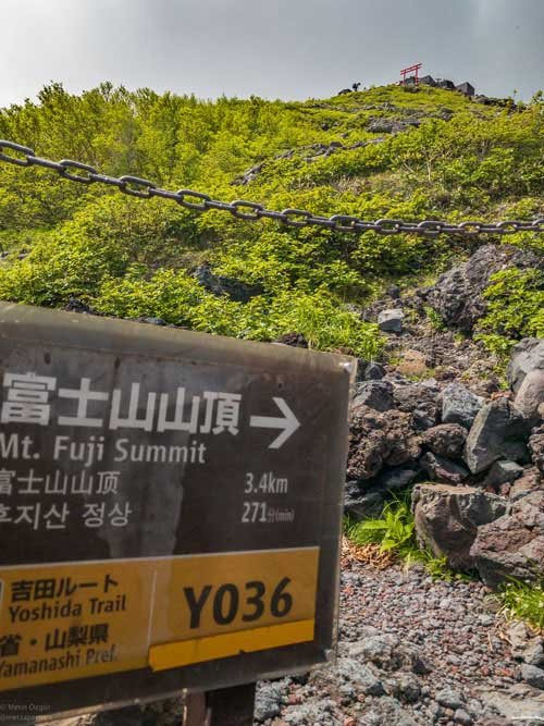
3.4 kilometers and 271 minutes to the summit.
There are many signs giving the time and distance information on the ascending and descending trails and they are very useful to keep you on the trail. Do not get disappointed if you feel like it is getting more time to reach your target than the sign says, most probably you are getting tired as you get closer to the summit :)

2 hours to the summit.
There are mountain huts and small shops on the ascending trail where you can buy drinks, snacks and use toilets. Only cash shopping is available and having many 100 Yen coins is recommended. On the other hand, there were no shops on the decending trail and there was only one toilet available on the descending trail, at least it was like that during my descend. So it is better to buy drinks and snacks at the summit if you need to.
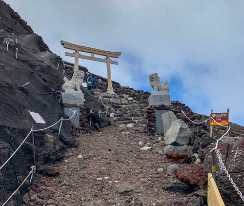
Last Torii before the summit.
I was very tired at this point and was not aware of that I was very close to the summit and gave a break on the rocks next to the lion statues. One of the climbers I've met during the climb gave me a hand and said 'you are almost there, give your break at the summit'. So I continued and was surprised that I reached at the summit after passing this torii. One of my regrets is that I forgot to have a picture in front of this torii.
View of the crater at the summit.
It is possible to take a tour around the crater at the summit but the crater trail was closed because of the weather conditions during my climb.
A short video from the summit
I think, the break I had on the summit of Fujisan was the best break I've ever had in my life until now :) I felt very relieved and had the taste of succeeding something important for myself.

Lake Kawaguchiko view from Mount Fuji summit.
After having a 30 minute break on the summit I started to descend. At first I thought it would be easier to descend but after a few minutes I realized that it will be more difficult than I thought. Using different muscles of the already tired legs and the structure of the ground on the descending trail made it more difficult. So if you think that descending will be easier, let me warn you it will not. I am adding a video of my descend and it seems easy in these videos bu it is not :)
Start of the descend.
Rescue team in training passing me during my break on descend.
Kawaguchiko and Fujiyoshida photographs
Here are some photograps from Lake Kawaguchiko, Fuji Sengen Shrine and Chureito Pagoda...


